The Tordrillo Mountains and Chuitna River Watershed
The Chuitna River begins its 25-mile journey in a landscape most Alaska visitors never see—the remote Tordrillo Mountains at the western edge of the Alaska Range. I’ve been flying to the Chuit for nearly three decades, and understanding this watershed’s unique characteristics helps explain why it fishes so differently from our glacial-fed systems.
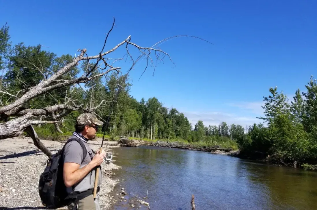
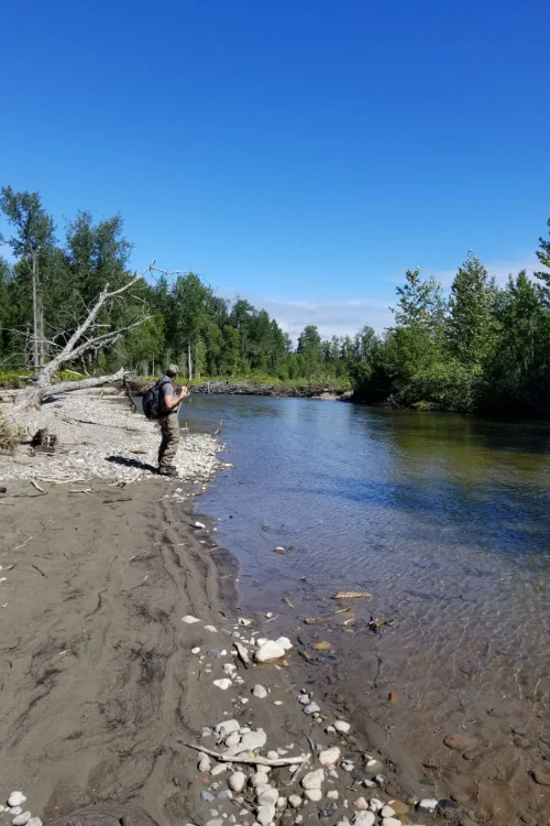
Unlike the Kenai or Kasilof, which run milky gray from glacial silt, the Chuitna flows tea-colored and mostly clear. That difference starts in the headwaters, where the river’s personality is shaped by the mountains that feed it.
The Tordrillo Mountains Formation and Character
The Tordrillo Mountains occupy a transitional zone where the Alaska Range meets the volcanic arc of the Aleutian Range. These peaks reach elevations just over 11,000 feet, with Mount Torbert being the highest at 11,413 feet. The range runs roughly 60 miles in a northeast-southwest orientation, creating a natural barrier between the interior drainage and the Cook Inlet slope.
What makes the Tordrillos particularly interesting is their volcanic history combined with heavy glaciation. While active volcanism has moved westward to peaks like Redoubt and Iliamna, the Tordrillo Mountains show evidence of past volcanic activity. The rock composition here differs from the purely sedimentary formations you see in some coastal ranges.
The glaciers in the Tordrillos are relatively small compared to the massive ice fields of the Chugach or Wrangell Mountains. This limited glaciation is precisely why the Chuitna runs clear rather than turbid. The river is primarily snow-fed, picking up runoff from the Tordrillo slopes without the heavy glacial flour that characterizes so many Southcentral Alaska rivers.
Snow-Fed Versus Glacier-Fed Rivers
The distinction between snow-fed and glacier-fed rivers matters enormously for fishing. Glacial rivers like the Kenai carry so much suspended sediment that visibility might be measured in inches. The Chuitna, fed by snowmelt and rainfall, maintains clarity that often exceeds several feet.
This clarity creates ideal conditions for sight-fishing and fly angling. Silver salmon in clear water behave differently than fish in turbid systems. They’re more selective, more likely to inspect offerings before striking, and far more exciting to watch when they do commit to a fly or lure.
The tea color comes from tannins leached from organic matter in the watershed—decomposing vegetation in muskeg and forest soils. It’s the same process that colors streams throughout Southeast Alaska and other temperate rainforest regions. The water looks dark from above but remains transparent enough to see the bottom in many sections.
Tyonek Native Lands and Access
The Chuitna River flows entirely through lands owned by the Tyonek Native Corporation and the Native Village of Tyonek. This ownership pattern stems from the Alaska Native Claims Settlement Act of 1971, which conveyed significant land holdings to Alaska Native corporations and villages.
Tyonek itself sits near the river’s terminus on the west side of Cook Inlet, roughly 50 miles west of Anchorage as the bush plane flies. The village has a long history—it’s been continuously occupied for thousands of years, positioned to take advantage of the productive fisheries where multiple river systems meet Cook Inlet.
The Tyonek people have managed access to the Chuitna carefully. Commercial development has been limited, and recreational access requires permission and coordination with tribal authorities. This controlled access has helped preserve the river’s character and prevented the overcrowding that affects more easily accessible fisheries.
When we arrange trips to the Chuitna, all transportation and access fees go through the Native Village. An awaiting transport meets us at the wilderness lake where the float plane lands, then shuttles us to the river. This system ensures the local community benefits from recreational use of their lands while maintaining oversight of how many people fish the river on any given day.
The West Cook Inlet Coastal Zone
The Chuitna is one of several rivers draining the western Cook Inlet slope in this region. The Beluga River lies to the north, the McArthur River to the south. Each has its own character, but they share the common feature of being relatively small, coastal systems with limited glacial influence.
Cook Inlet itself creates the conditions these rivers experience. The inlet has one of the largest tidal ranges in North America—differences of 30 feet or more between high and low tide. These extreme tides push saltwater influence far up the lower reaches of rivers like the Chuitna, creating brackish zones where salmon stage before moving into pure fresh water.
The west side of Cook Inlet receives more precipitation than the Kenai Peninsula across the water. The prevailing weather patterns push moisture-laden air from the Gulf of Alaska inland, where it hits the Tordrillo and Alaska Range mountains and drops heavy rainfall. This precipitation pattern keeps the Chuitna flowing year-round, unlike some interior rivers that can run low in late summer.
Watershed Size and Flow Characteristics
The Chuitna’s relatively small watershed—approximately 200 square miles—means the river responds quickly to weather events. A heavy rainstorm can raise water levels and reduce clarity within hours. Conversely, after a few days of dry weather, the river drops and clears rapidly.
This responsive nature affects trip planning. Unlike larger rivers with more stable flows, the Chuitna can change character overnight. After three decades of flying here, I’ve learned to watch weather patterns in the Tordrillos closely. A low-pressure system sitting over the Alaska Range can mean postponing trips until conditions improve.
The river’s gradient is moderate—dropping roughly 1,500 feet over its 25-mile course. This creates a mix of riffle, run, and pool structure that salmon utilize differently depending on water levels. The lower river near tidewater tends to be slower and deeper, while the upper sections near the headwaters feature faster water and more pronounced gravel bars.
Historical Context of the King Salmon Closure
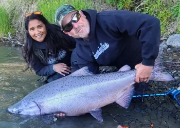
 The Chuitna was once renowned for its king salmon run. The combination of a small, clear river and large chinook created the kind of fishing that builds reputations. Kings in the 40-pound range were regular occurrences, with fish occasionally pushing into the 50s.
The closure of king fishing in 2011 reflected broader conservation concerns across Cook Inlet drainages. Multiple factors contributed to declining returns: ocean conditions, competition for forage, and the cumulative effects of harvest over many years. The Alaska Department of Fish and Game implemented the closure to allow the stock to rebuild.
While the loss of the king fishery was disappointing, the silver salmon run remained strong. These coho enter the system later than in many rivers—late July through early September—making the Chuitna an excellent option when fishing slows on the Kenai Peninsula’s more accessible waters.
The village of Tyonek has been involved in discussions about potential coal development in the Chuitna watershed. Any such development would have significant implications for the river’s fisheries. For now, the drainage remains largely undeveloped, and the silver salmon continue returning in numbers that support a sustainable recreational fishery.
When you make the 30-minute flight from North Kenai to fish the Chuitna, you’re accessing a river system that represents a different Alaska than the road-accessible drainages. The Tordrillo Mountains backdrop, the clear water, and the limited human presence create fishing conditions you won’t find along the highway system. Book a Chuitna River fly-in fishing trip today with Mark Glassmaker
Mark and Cindy Glassmaker have been married for 28 years, and their business, Alaska Fishing with Mark Glassmaker, has been operating since 1990. Over the past 34 years guiding on the Kenai River, we’ve witnessed many changes. Through early diversification and the dedication of our entire guide staff and team, we’ve built and maintained what we believe is the premier Kenai River fishing experience.
We take great pride in our work and in the reputation our business stands for. Your trip becomes part of that legacy, and we are committed to making it exceptional. Every outing is approached with 100% effort and service, ensuring that your Alaska fishing trips not only meets but exceeds expectations.